South-east Queensland hit by very dangerous thunderstorms as hail up to 13cm pummels the region
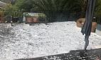
Hail up to 13 centimetres has been reported at Hillcrest, south of Brisbane, as parts of south-east Queensland were pummelled by a series of very dangerous and “life threatening” thunderstorms this afternoon.
Hail storms also battered southern Sydney and parts of the New South Wales south coast were warned about flash flooding as an “unstable” weather system moved across the state.
The Bureau of Meteorology (BOM) issued warnings for people in parts of Queensland’s Wide Bay, Burnett, Darling Downs and Granite Belt regions earlier this afternoon.

The BOM warned the situation was volatile and continuing to change quickly
The areas likely to be hit hardest stretch from the Queensland border to north of the Sunshine Coast and communities further inland.
More than 40,000 homes without power
Energex said more than 40,000 homes and businesses are currently without power, most in Logan and the Gold Coast.
Energex spokesperson Justin Coomber said more than 76 downed powerlines had already been reported along with 180,000 lightning strikes.
“It’s early days but it’s looking like the major issues are high winds — we’ve heard of 80 kilometre an hour winds recorded and also lightning strikes,” he said.

Mr Coomber said it was too early to say how soon power would be restored to areas as more storms were expected to hit the state.
“As soon as it’s safe to do so … our crews are out there and ready to go, and we’ve brought crews in from other areas as well to bolster the numbers in the worst hit areas,” he said.
He urged people to seek shelter and those out with children trick-or-treating to be especially cautious of downed powerlines.
Earlier today BOM forecaster Kimba Wong said three very dangerous thunderstorms were moving east but more storms could develop.
“One’s just to the north-east of Toowoomba, another through the Lockyer Valley, and another tracking just to the south of Ipswich towards Jimboomba at the moment,” she said.
“We’ve had some giant hail observations from that storm that’s tracking towards Jimboomba … round Gatton and also around Adare so very, very dangerous thunderstorms moving through the south-east at the moment.
“There’s potential for further giant hail to come from these storms and also the potential for some destructive wind gusts in excess of 125 kilometres per hour as well.”
Ms Wong said storms could continue to develop through the afternoon and into the evening.

He said the situation would remain dynamic for the rest of the afternoon so people should keep aware of any local warnings and prepare accordingly.
“We’re expecting it to clear as we head through the overnight hours and so it should be a much clearer day, particularly around Brisbane and the Gold Coast as we head in to tomorrow,” she said.

The forecast suggests showers may linger further north on the Sunshine Coast and Wide Bay tomorrow but should not develop into severe thunderstorms.
At 1:17pm the BOM issued a warning for severe thunderstorms that were rapidly developing, especially south of Kingaroy.
“Severe thunderstorms are likely to produce giant hailstones, destructive winds and heavy rainfall that may lead to flash flooding over the next several hours,” the BOM stated.

Other locations affected included Gympie, Gayndah and Caboolture.
Earlier today the BOM also warned of potential flash flooding in Brisbane, with more than 60 millimetres of rain expected to be dumped on the city.

However, BOM forecaster James Thompson said the flooding would not be widespread.
“With the recent rainfall it means the catchments are a little more primed than they were earlier in the week, so with heavy rainfall we could see flash flooding,” he said.

The storms are expected to extend into Western Queensland, east of Dalby and Chinchilla in the Darling Downs and east of Clermont in the Central Highlands.
Areas south of Gladstone, Biloela and Thangool, and parts of the Sunshine Coast, Brisbane and Gold Coast could also be affected.
NSW also hit by hail
Meanwhile, parts of Sydney have been showered in hail and BOM has warned there may be more to come as a low pressure system moves over New South Wales.
Severe thunderstorm warnings are in place for much of NSW, including the Northern Rivers, the Riverina and South Coast.
Sydney’s Sutherland Shire was pelted by 3cm hail around 1:00pm and a warning is still in place for “large, possibly giant hailstones”.
Heavy rain and damaging winds are also battering southern Sydney and Wollongong.
Fire and rescue crews attended the Woolworths in Albion Park, south of Wollongong, after the roof collapsed and caused the store to flood.