Gold Coast beaches closed as big swell, heavy rainfall hits south-east Queensland
The Bureau of Meteorology has issued a severe weather warning for areas from the south-east coast of Queensland to the New South Wales border, as well as parts of the Wide Bay and Burnett regions.
Key points:
The BOM said the average wave height off the coast was about five metres, with spikes up to 10m
Flood warnings are active for much of the region and the SES has had more than 500 calls for assistance
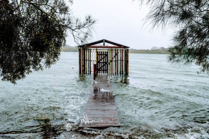
All Gold Coast beaches were closed on Sunday as conditions deteriorated
Heavy rain, damaging winds, abnormally high tides and dangerous surf hit the region on Saturday as a surface trough deepened off the coast.
Sunday’s heaviest rainfall for the Gold Coast eased before 7:00pm AEST, but the Bureau of Meteorology (BOM) forecast more rain, high tides and gale-force winds into Monday, issuing a flood watch notice from Fraser Island down to the NSW border.
In the Gold Coast hinterland, 475 millimetres of rain fell in Upper Springbrook in the 24 hours to 9:00am on Sunday, with more than 300 millimetres of that falling in six hours overnight Senior BOM forecaster Shane Kennedy said the intense rainfall in locations such as Springbrook was extremely rare.
“Just in the six-hour period ending roughly about 3:00am, [Springbrook] got 323mm so that’s a less than a 1 per cent chance we’d generally see that — so more than a one-in-100-year event,” he said. The BOM said rainfall in the region was higher than expected on Saturday night, when a convergence line stalled over the Queensland-New South Wales border after moving up from the south.
The SES has had more than 520 requests for assistance since 6:00pm on Saturday night, with most jobs in the Ipswich, Logan and Gold Coast areas.
‘Very dangerous’ 10-metre waves
The BOM said beach conditions from Fraser Island down to the New South Wales border were “very dangerous”. Meteorologist Rosa Hoff said the average wave height was five metres.
“We’ve already seen some spikes up to nine and even 10 metres occurring off the Brisbane wave-monitoring gauge,” she said.
A hazardous surf warning was issued from Hervey Bay down to Gold Coast waters, with coastal erosion expected.
The surf is being whipped up by strong to gale-force winds, with damaging gusts of up to 100kph recorded at Cape Moreton.
In NSW, a flood watch and severe weather warning is also in place for heavy rain, damaging winds, abnormally high tides and damaging surf for the Northern Rivers and parts of the Mid North Coast.
Areas affected include Tweed Heads, Byron Bay, Lismore, Kyogle, Yamba, Grafton, Coffs Harbour, Maclean, Woolgoolga, Sawtell and Dorrigo . Surf Life Saving Queensland (SLSQ) closed all Gold Coast beaches on Sunday due to dangerous surf conditions.
“Please stay out of the water,” SLSQ posted on social media.
“Due to strong outgoing tides and debris, now is not the time to go swimming in creeks.”
There were also reports of flooding at Maroochydore on the Sunshine Coast. With a number of roads already closed, the Gold Coast council urged drivers not to drive through floodwaters.
It said maintenance crews would respond to safety concerns, and sandbagging stations would be open at Pimpama and Bilinga from 9:00am.
With a number of roads already closed, the Gold Coast council urged drivers not to drive through floodwaters.
It said maintenance crews would respond to safety concerns, and sandbagging stations would be open at P Gold Coast mayor Tom Tate said the worst of the weather was predicted to hit in the early hours of Monday morning.
“The weather event is not over yet. As a matter of fact, [it is] only halfway through,” he said.
“Looking at the weather map, it appears 2:00am is when it’s going to hit us the most. Potentially it could be another 200mm, so [we’re] only halfway [through].”
He said beaches would remain closed while sandbagging stations in the region would be shut from 6:00pm due to safety reasons. Brisbane picked up between 20 and 40mm of rain, but falls were as high as 70mm in southern suburbs such as Beenleigh, Logan and Rochedale.
With further heavy rain possible, the BOM issued a flood warning for the Logan and Albert rivers about 2:00pm on Saturday.
Not much rain has made its way inland, with between five and 15mm falling in gauges on the eastern Darling Downs. Mr Ryan said the areas from Bundaberg to the South Coast could be affected.
“The following catchments could be affected: the Mary River, Noosa River, Sunshine Coast River and creeks, Pine and Caboolture rivers, the upper Brisbane River, the lower Brisbane River, Gold Coast rivers and creeks. We already have flood warnings on the Albert and Logan rivers,” he said.
Emergency Services Commissioner Greg Leach said rain that had fallen over the past 24 hours had now “sunk in” and there was a possibility for low level and flash flooding.
“The State Emergency Service has received over 530 requests for assistance over the last 24 hours and they are still responding to some of those calls, with water leaks, roof damage and trees down,” he said.
“If you have loose items in your backyard and you get a bit of a low in the weather, go out and secure those items and please keep children away from floodwaters in the event that you get flooding at your property.
“What we are seeing is a significant change in the weather pattern in Queensland. The wet season has arrived. Only last week we were dealing with bushfire situations but now the big wet has arrived and we need to be prepared for the weather we are dealing with now but we are likely to see over the coming months.”
Mr Leach said anyone who found themselves trapped in floodwaters should call triple-0.
Rainfall helps contain Fraser Island fire
m1 blocked
A large tree has fallen across lanes of the M1, near exit 71.(Supplied: Christine Chaplin)
Queensland Fire and Emergency Services (QFES) said the rain had helped bring the fire at Fraser Island (K’Gari) under control.
“With the help of welcome rainfall and a massive response from our crews, as well as the local community and our partners from Queensland Parks and Wildlife Service (QPWS) and the Butchulla Aboriginal Corporation, the fire is now contained,” QFES said.
“QFES is today handing back control of the fire to QPWS, but our crews will remain on the ground patrolling to ensure the community remain safe.”
Burnt landscape with some green trees as well.
QFES aerial photo shows the burnt vegetation on Fraser Island.(Supplied: QFES)
Motorists work together to clear road
Tamborine Mountain Road was blocked by a large tree that had fallen in yesterday’s wet weather on the Gold Coast hinterland.
People waiting in cars and buses who had been waiting for assistance banded together and helped clear the blocked road.
The tree was moved in 20 minutes.
A spokesperson from Pineapple Tours said all passengers on their tour bus also joined in, and the alternative was to turn around which would have taken an hour at least ABC